This GPS Map Camera app cleverly integrates camera functions with precise GPS location tracking. Its features, including geotagging, GPS scanning, and GPS mapping, let users visually document their journeys. The app provides a powerful mapping system for viewing photos on a GPS map, effectively creating a visual travelogue. Beyond its core camera capabilities, it allows users to add GPS location data to existing photos, transforming any image into a geotagged memory. Its intuitive design ensures seamless operation on GPS-enabled devices. Whether you're a seasoned photographer or a casual picture-taker, this app is an invaluable tool for adding geolocation information to your photographic collection.
The GPS Map Camera App boasts six key benefits:
-
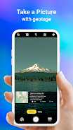
Integrated Camera and GPS: Capture photos and instantly geotagging them with precise location data, creating a visual travel diary.
-
Versatile Photo Capture and Tracking: Use the built-in GPS camera or add location data to existing photos using the app's geotagging feature.
-
Comprehensive Mapping: Easily view photos on an integrated GPS map, showing the exact location of each shot within your travel route.
-
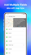
Customizable Date/Time Stamps: Choose and add date and time stamps to your photos for enhanced organization.
-
Customizable Photo Management: Save photos with custom names and utilize live navigation for effortless organization.
-
Lightweight Alternative: A Lite version provides many of the full app's features while minimizing device storage usage.


v1.1.6
5.00M
Android 5.1 or later
com.locationonphoto.gpsmapcamera.geotagging.gpscam